地址: 15100 (From 15100 To 15199) UNIANDEL RD, DOBSON, NC 27017-9744, USA
27017-9744是什麼 27017-9744是 15100 (From 15100 To 15199) UNIANDEL RD, DOBSON, NC, USA的5加4位邮编。下面是详细信息。
27017-9744基本信息

-
郵政編碼5加4:
27017-9744 -
郵政編碼5:
27017 -
加4?97444-digits that are used to identify a geographic segment within the 5-digit delivery area, such as a city block or a group of apartments or an individual high-volume receiver of mail, or any other unit that could use an extra identifier to aid in efficient mail sorting and delivery. This code is the low end of the range of +4 Codes that pertain to this ZIP Code. ZIP+4 Codes associated with nondelivery areas are composed of valid ZIP sector numbers and "ND" for the ZIP segment number, for example 12345-12ND. Non-deliverable areas are areas to which the USPS does not deliver mail, such as vacant lots and land that borders railroad tracks. Mailers should not match an address identified as a nondelivery area. If you absolutely must have numeric characters in the Plus4Code column, you may treat "ND" values as "00" (zero zero).:
-
國家:
U.S. - 美國 -
州:
NC - 北卡羅萊納州 -
區縣:
CountyFIPS: 37171 - Surry County -
城市:
DOBSON -
街道?UNIANDEL RDThe official name of a street as assigned by a local governing authority. The Street Name column contains only the street name and does not include directionals (EAST, WEST, etc.) or suffixes (ST, DR, BLVD, etc.). This element may also contain literals, such as PO BOX, GENERAL DELIVERY, USS, PSC, or UNIT. Numeric street names that have numeric components that are four characters (or less) in length at are justified such that the low-order digit of the number is positioned in the fourth position of the street name column. This shift is made so that the numeric street names appear in numeric sequence.:
-
街道後綴?RD (道路)The street suffix: For Example: ST = Street RD = Road DR = Drive LN = Lane:
-
記錄類型?S: 街道An alphabetic value that identifies the type of data in the record. Record type codes include the following: G = General delivery H = Highrise F = Firm S = Street P = PO box R = Rural route/highway contract:
地址

- 主要地址地位數字?
A house, rural route, highway contract box, or post office box number; the numeric or alphanumeric component of an address preceding the street name; the low-end address in a range of addresses. Often referred to as house number.: 15100
- 主要地址高位數字?
A house, rural route, contract box, or Post Office box number. The numeric or alphanumeric component of an address preceding the street name. The high-end address in a range of addresses. Often referred to as house number.: 15199
- 主要地址奇/偶碼?
Code that identifies the side or sides of a street for which a given address range is applicable. For street, highrise, firm and multi-carrier records, B = Both sides of a street, E = Even side of a street (even-numbered addresses in the range); O = Odd side of a street (odd-numbered addresses in the range). For general delivery, post office box, and rural route/highway contract records, this code will always be "B" (both).: Both of Odd and Even
- 主要範圍: 15100, 15101, 15102, 15103, 15104, 15105, 15106, 15107, 15108, 15109, 15110, 15111, 15112, 15113, 15114, 15115, 15116, 15117, 15118, 15119, 15120, 15121, 15122, 15123, 15124, 15125, 15126, 15127, 15128, 15129, 15130, 15131, 15132, 15133, 15134, 15135, 15136, 15137, 15138, 15139, 15140, 15141, 15142, 15143, 15144, 15145, 15146, 15147, 15148, 15149, 15150, 15151, 15152, 15153, 15154, 15155, 15156, 15157, 15158, 15159, 15160, 15161, 15162, 15163, 15164, 15165, 15166, 15167, 15168, 15169, 15170, 15171, 15172, 15173, 15174, 15175, 15176, 15177, 15178, 15179, 15180, 15181, 15182, 15183, 15184, 15185, 15186, 15187, 15188, 15189, 15190, 15191, 15192, 15193, 15194, 15195, 15196, 15197, 15198, 15199.
請單擊"更多地址示例"查看整個列表。
15100 UNIANDEL RD, DOBSON, NC 27017-9744
15101 UNIANDEL RD, DOBSON, NC 27017-9744
15102 UNIANDEL RD, DOBSON, NC 27017-9744
15103 UNIANDEL RD, DOBSON, NC 27017-9744
15104 UNIANDEL RD, DOBSON, NC 27017-9744
15105 UNIANDEL RD, DOBSON, NC 27017-9744
15106 UNIANDEL RD, DOBSON, NC 27017-9744
15107 UNIANDEL RD, DOBSON, NC 27017-9744
15108 UNIANDEL RD, DOBSON, NC 27017-9744
15109 UNIANDEL RD, DOBSON, NC 27017-9744
15110 UNIANDEL RD, DOBSON, NC 27017-9744
15111 UNIANDEL RD, DOBSON, NC 27017-9744
15112 UNIANDEL RD, DOBSON, NC 27017-9744
15113 UNIANDEL RD, DOBSON, NC 27017-9744
15114 UNIANDEL RD, DOBSON, NC 27017-9744
15115 UNIANDEL RD, DOBSON, NC 27017-9744
15116 UNIANDEL RD, DOBSON, NC 27017-9744
15117 UNIANDEL RD, DOBSON, NC 27017-9744
15118 UNIANDEL RD, DOBSON, NC 27017-9744
15119 UNIANDEL RD, DOBSON, NC 27017-9744
15120 UNIANDEL RD, DOBSON, NC 27017-9744
15121 UNIANDEL RD, DOBSON, NC 27017-9744
15122 UNIANDEL RD, DOBSON, NC 27017-9744
15123 UNIANDEL RD, DOBSON, NC 27017-9744
15124 UNIANDEL RD, DOBSON, NC 27017-9744
15125 UNIANDEL RD, DOBSON, NC 27017-9744
15126 UNIANDEL RD, DOBSON, NC 27017-9744
15127 UNIANDEL RD, DOBSON, NC 27017-9744
15128 UNIANDEL RD, DOBSON, NC 27017-9744
15129 UNIANDEL RD, DOBSON, NC 27017-9744
15130 UNIANDEL RD, DOBSON, NC 27017-9744
15131 UNIANDEL RD, DOBSON, NC 27017-9744
15132 UNIANDEL RD, DOBSON, NC 27017-9744
15133 UNIANDEL RD, DOBSON, NC 27017-9744
15134 UNIANDEL RD, DOBSON, NC 27017-9744
15135 UNIANDEL RD, DOBSON, NC 27017-9744
15136 UNIANDEL RD, DOBSON, NC 27017-9744
15137 UNIANDEL RD, DOBSON, NC 27017-9744
15138 UNIANDEL RD, DOBSON, NC 27017-9744
15139 UNIANDEL RD, DOBSON, NC 27017-9744
15140 UNIANDEL RD, DOBSON, NC 27017-9744
15141 UNIANDEL RD, DOBSON, NC 27017-9744
15142 UNIANDEL RD, DOBSON, NC 27017-9744
15143 UNIANDEL RD, DOBSON, NC 27017-9744
15144 UNIANDEL RD, DOBSON, NC 27017-9744
15145 UNIANDEL RD, DOBSON, NC 27017-9744
15146 UNIANDEL RD, DOBSON, NC 27017-9744
15147 UNIANDEL RD, DOBSON, NC 27017-9744
15148 UNIANDEL RD, DOBSON, NC 27017-9744
15149 UNIANDEL RD, DOBSON, NC 27017-9744
15150 UNIANDEL RD, DOBSON, NC 27017-9744
15151 UNIANDEL RD, DOBSON, NC 27017-9744
15152 UNIANDEL RD, DOBSON, NC 27017-9744
15153 UNIANDEL RD, DOBSON, NC 27017-9744
15154 UNIANDEL RD, DOBSON, NC 27017-9744
15155 UNIANDEL RD, DOBSON, NC 27017-9744
15156 UNIANDEL RD, DOBSON, NC 27017-9744
15157 UNIANDEL RD, DOBSON, NC 27017-9744
15158 UNIANDEL RD, DOBSON, NC 27017-9744
15159 UNIANDEL RD, DOBSON, NC 27017-9744
15160 UNIANDEL RD, DOBSON, NC 27017-9744
15161 UNIANDEL RD, DOBSON, NC 27017-9744
15162 UNIANDEL RD, DOBSON, NC 27017-9744
15163 UNIANDEL RD, DOBSON, NC 27017-9744
15164 UNIANDEL RD, DOBSON, NC 27017-9744
15165 UNIANDEL RD, DOBSON, NC 27017-9744
15166 UNIANDEL RD, DOBSON, NC 27017-9744
15167 UNIANDEL RD, DOBSON, NC 27017-9744
15168 UNIANDEL RD, DOBSON, NC 27017-9744
15169 UNIANDEL RD, DOBSON, NC 27017-9744
15170 UNIANDEL RD, DOBSON, NC 27017-9744
15171 UNIANDEL RD, DOBSON, NC 27017-9744
15172 UNIANDEL RD, DOBSON, NC 27017-9744
15173 UNIANDEL RD, DOBSON, NC 27017-9744
15174 UNIANDEL RD, DOBSON, NC 27017-9744
15175 UNIANDEL RD, DOBSON, NC 27017-9744
15176 UNIANDEL RD, DOBSON, NC 27017-9744
15177 UNIANDEL RD, DOBSON, NC 27017-9744
15178 UNIANDEL RD, DOBSON, NC 27017-9744
15179 UNIANDEL RD, DOBSON, NC 27017-9744
15180 UNIANDEL RD, DOBSON, NC 27017-9744
15181 UNIANDEL RD, DOBSON, NC 27017-9744
15182 UNIANDEL RD, DOBSON, NC 27017-9744
15183 UNIANDEL RD, DOBSON, NC 27017-9744
15184 UNIANDEL RD, DOBSON, NC 27017-9744
15185 UNIANDEL RD, DOBSON, NC 27017-9744
15186 UNIANDEL RD, DOBSON, NC 27017-9744
15187 UNIANDEL RD, DOBSON, NC 27017-9744
15188 UNIANDEL RD, DOBSON, NC 27017-9744
15189 UNIANDEL RD, DOBSON, NC 27017-9744
15190 UNIANDEL RD, DOBSON, NC 27017-9744
15191 UNIANDEL RD, DOBSON, NC 27017-9744
15192 UNIANDEL RD, DOBSON, NC 27017-9744
15193 UNIANDEL RD, DOBSON, NC 27017-9744
15194 UNIANDEL RD, DOBSON, NC 27017-9744
15195 UNIANDEL RD, DOBSON, NC 27017-9744
15196 UNIANDEL RD, DOBSON, NC 27017-9744
15197 UNIANDEL RD, DOBSON, NC 27017-9744
15198 UNIANDEL RD, DOBSON, NC 27017-9744
15199 UNIANDEL RD, DOBSON, NC 27017-9744
地址範例
DOBSON NC 27017-9744
UNITED STATES OF AMERICA
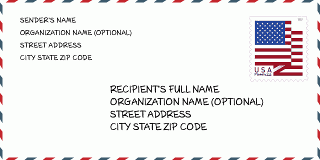
27017-9744信封例子

-
這是美國信封例子。在左上角填寫發件人信息,右下角填寫收件人信息。必須要填寫的信息有發件人和收件人的姓名、街道地址、城市、州還有郵政編碼。收件人的地址示例僅供參考。通常來說,如果你不確定九位郵件,你可以僅僅填寫五位郵編,以避免郵件丟失。
27017-9744基本含義
-
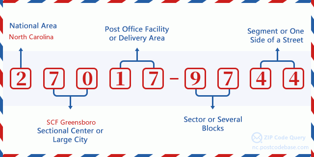
郵政編碼 27017-9744 的每個數字代表什麼?ZIP+4 Code由兩部分組成,前五位數字可以定位到郵局,後四位數字可以確定五位數字遞送區域內的一個地理區段。 6-7位數字指定區域或幾個街區,8-9位數字指定區段或街道的一側。

- ·運輸路線ID?
A 4-digit code assigned to a mail delivery or collection route within a 5-digit ZIP Code. The first character of this identification is alphabetical, and the last three are numeric: Bnnn = PO box Hnnn = Highway contract Rnnn = Rural route Cnnn = City delivery Gnnn = General delivery: R002 (農村路線)
- ·郵遞附加低部?
The ZIP Add-On Low Sector and the ZIP Add-On Low Segment together form the ZIP Add-On Low Number. The ZIP Add-On Low Number is the last four positions of a ZIP+4 code; the low-end ZIP add-on in a range of codes; the add-on of the first ZIP+4 code in a consecutive series of ZIP+4 codes assigned to the delivery address. For example, most delivery addresses are assigned a single ZIP+4 code. However, large companies may be given a range of ZIP+4 codes that can be used to route mail to specific departments. A range of ZIP+4 codes can also be assigned to a corresponding range of post office boxes, and each box is mapped, one-to-one, with a ZIP+4 code in the range. A single post office box can also be assigned a range of ZIP+4 codes.: 97
- ·郵遞附加低段?
The ZIP Add-On Low Sector and the ZIP Add-On Low Segment together form the ZIP Add-On Low Number. The ZIP Add-On Low Number is the last four positions of a ZIP+4 code; the low-end ZIP add-on in a range of codes; the add-on of the first ZIP+4 code in a consecutive series of ZIP+4 codes assigned to the delivery address. For example, most delivery addresses are assigned a single ZIP+4 code. However, large companies may be given a range of ZIP+4 codes that can be used to route mail to specific departments. A range of ZIP+4 codes can also be assigned to a corresponding range of post office boxes, and each box is mapped, one-to-one, with a ZIP+4 code in the range. A single post office box can also be assigned a range of ZIP+4 codes.: 44
- ·郵遞附加高部?
The ZIP Add-On High Sector and the ZIP Add-On High Segment together form the ZIP Add-On High Number, which is the high-end ZIP add-on in a range of codes; the add-on of the last ZIP+4 code in a consecutive series of ZIP+4 codes assigned to the delivery address. Most delivery addresses are assigned a single ZIP+4 code; however, large companies may be given a range of ZIP+4 codes that can be used to route mail to specific departments. A range of ZIP+4 codes can also be assigned to a corresponding range of post office boxes, and each box is mapped, one-to-one, with a ZIP+4 code in the range. A single post office box can also be assigned a range of ZIP+4 codes. (See also ZIP Add-On Code.): 97
- ·郵遞附加高段?
The ZIP Add-On High Sector and the ZIP Add-On High Segment together form the ZIP Add-On High Number, which is the high-end ZIP add-on in a range of codes; the add-on of the last ZIP+4 code in a consecutive series of ZIP+4 codes assigned to the delivery address. Most delivery addresses are assigned a single ZIP+4 code; however, large companies may be given a range of ZIP+4 codes that can be used to route mail to specific departments. A range of ZIP+4 codes can also be assigned to a corresponding range of post office boxes, and each box is mapped, one-to-one, with a ZIP+4 code in the range. A single post office box can also be assigned a range of ZIP+4 codes. (See also ZIP Add-On Code.): 44
- ·郵政編碼附加: 9744
- ·範圍?
The range of +4 codes. Summing the +4 Code and the +4 Range will give you the high end of the range of +4 Codes that pertain to this ZIP Code.: 0
- ·基本替代代碼?
Code that specifies whether a record is a base (preferred) or alternate record. Base records (represented as "B") can represent a range of addresses or an individual address, such as a firm record, while alternate records (represented as "A") are individual delivery points. Government deliveries will only be listed on alternate records with the appropriate government building indicator (federal, state, or city) set.: 基本
- ·財務數字?
A code assigned to Postal Service facilities (primarily post offices) to collect cost and statistical data and compile revenue and expense data. The state number comprises the first two positions of the finance number.: 362120
- ·國會分區號碼?
A standard value identifying a geographic area within the United States served by a member of the US House of Representatives or Senate. If Army/Air Force (APO) or fleet post office (FPO), this column will be blank. If there is only one member of Congress within a state, the code will be "AL" (at large).: 05
- ·最後行市州代碼?
An index to the City State file that provides the preferred last-line name for this address range.: Y15139
在線地圖

这是地址15100 UNIANDEL RD, DOBSON匹配的在线电子地图。您可以使用图中按钮来移动、缩放。该地图信息仅供参考。
地址: 15100 (From 15100 To 15199) UNIANDEL RD, DOBSON, NC 27017-9744, USA
回應


發表新回應