주소: 6700 (From 6700 To 6799) MEASHALL RD, ARARAT, NC 27007-6700, USA
27007-6700은 무엇입니까? 27007-6700 6700 (From 6700 To 6799) MEASHALL RD, ARARAT, NC, USA 의 5플러스 4 우편번호입니다. 다음은 세부정보입니다.
27007-6700 기본 정보

-
우편 번호 5 플러스 4:
27007-6700 -
우편 번호 5:
27007 -
플러스 4?67004-digits that are used to identify a geographic segment within the 5-digit delivery area, such as a city block or a group of apartments or an individual high-volume receiver of mail, or any other unit that could use an extra identifier to aid in efficient mail sorting and delivery. This code is the low end of the range of +4 Codes that pertain to this ZIP Code. ZIP+4 Codes associated with nondelivery areas are composed of valid ZIP sector numbers and "ND" for the ZIP segment number, for example 12345-12ND. Non-deliverable areas are areas to which the USPS does not deliver mail, such as vacant lots and land that borders railroad tracks. Mailers should not match an address identified as a nondelivery area. If you absolutely must have numeric characters in the Plus4Code column, you may treat "ND" values as "00" (zero zero).:
-
나라:
U.S. - 미국 -
주:
NC - 노스 캐롤라이나 -
군:
CountyFIPS: 37171 - Surry County -
도시:
ARARAT -
거리?MEASHALL RDThe official name of a street as assigned by a local governing authority. The Street Name column contains only the street name and does not include directionals (EAST, WEST, etc.) or suffixes (ST, DR, BLVD, etc.). This element may also contain literals, such as PO BOX, GENERAL DELIVERY, USS, PSC, or UNIT. Numeric street names that have numeric components that are four characters (or less) in length at are justified such that the low-order digit of the number is positioned in the fourth position of the street name column. This shift is made so that the numeric street names appear in numeric sequence.:
-
거리 접미사?RD (도로)The street suffix: For Example: ST = Street RD = Road DR = Drive LN = Lane:
-
기록 유형?S: 거리An alphabetic value that identifies the type of data in the record. Record type codes include the following: G = General delivery H = Highrise F = Firm S = Street P = PO box R = Rural route/highway contract:
주소

- 주요 주소 낮은 수치?
A house, rural route, highway contract box, or post office box number; the numeric or alphanumeric component of an address preceding the street name; the low-end address in a range of addresses. Often referred to as house number.: 6700
- 주요 주소 높은 수치?
A house, rural route, contract box, or Post Office box number. The numeric or alphanumeric component of an address preceding the street name. The high-end address in a range of addresses. Often referred to as house number.: 6799
- 주요 주소 홀수/짝수 코드?
Code that identifies the side or sides of a street for which a given address range is applicable. For street, highrise, firm and multi-carrier records, B = Both sides of a street, E = Even side of a street (even-numbered addresses in the range); O = Odd side of a street (odd-numbered addresses in the range). For general delivery, post office box, and rural route/highway contract records, this code will always be "B" (both).: Both of Odd and Even
- 일 순위 범위: 6700, 6701, 6702, 6703, 6704, 6705, 6706, 6707, 6708, 6709, 6710, 6711, 6712, 6713, 6714, 6715, 6716, 6717, 6718, 6719, 6720, 6721, 6722, 6723, 6724, 6725, 6726, 6727, 6728, 6729, 6730, 6731, 6732, 6733, 6734, 6735, 6736, 6737, 6738, 6739, 6740, 6741, 6742, 6743, 6744, 6745, 6746, 6747, 6748, 6749, 6750, 6751, 6752, 6753, 6754, 6755, 6756, 6757, 6758, 6759, 6760, 6761, 6762, 6763, 6764, 6765, 6766, 6767, 6768, 6769, 6770, 6771, 6772, 6773, 6774, 6775, 6776, 6777, 6778, 6779, 6780, 6781, 6782, 6783, 6784, 6785, 6786, 6787, 6788, 6789, 6790, 6791, 6792, 6793, 6794, 6795, 6796, 6797, 6798, 6799.
전체 목록을 보려면 "더 많은 주소 예시"을 클릭하십시오.
6700 MEASHALL RD, ARARAT, NC 27007-6700
6701 MEASHALL RD, ARARAT, NC 27007-6700
6702 MEASHALL RD, ARARAT, NC 27007-6700
6703 MEASHALL RD, ARARAT, NC 27007-6700
6704 MEASHALL RD, ARARAT, NC 27007-6700
6705 MEASHALL RD, ARARAT, NC 27007-6700
6706 MEASHALL RD, ARARAT, NC 27007-6700
6707 MEASHALL RD, ARARAT, NC 27007-6700
6708 MEASHALL RD, ARARAT, NC 27007-6700
6709 MEASHALL RD, ARARAT, NC 27007-6700
6710 MEASHALL RD, ARARAT, NC 27007-6700
6711 MEASHALL RD, ARARAT, NC 27007-6700
6712 MEASHALL RD, ARARAT, NC 27007-6700
6713 MEASHALL RD, ARARAT, NC 27007-6700
6714 MEASHALL RD, ARARAT, NC 27007-6700
6715 MEASHALL RD, ARARAT, NC 27007-6700
6716 MEASHALL RD, ARARAT, NC 27007-6700
6717 MEASHALL RD, ARARAT, NC 27007-6700
6718 MEASHALL RD, ARARAT, NC 27007-6700
6719 MEASHALL RD, ARARAT, NC 27007-6700
6720 MEASHALL RD, ARARAT, NC 27007-6700
6721 MEASHALL RD, ARARAT, NC 27007-6700
6722 MEASHALL RD, ARARAT, NC 27007-6700
6723 MEASHALL RD, ARARAT, NC 27007-6700
6724 MEASHALL RD, ARARAT, NC 27007-6700
6725 MEASHALL RD, ARARAT, NC 27007-6700
6726 MEASHALL RD, ARARAT, NC 27007-6700
6727 MEASHALL RD, ARARAT, NC 27007-6700
6728 MEASHALL RD, ARARAT, NC 27007-6700
6729 MEASHALL RD, ARARAT, NC 27007-6700
6730 MEASHALL RD, ARARAT, NC 27007-6700
6731 MEASHALL RD, ARARAT, NC 27007-6700
6732 MEASHALL RD, ARARAT, NC 27007-6700
6733 MEASHALL RD, ARARAT, NC 27007-6700
6734 MEASHALL RD, ARARAT, NC 27007-6700
6735 MEASHALL RD, ARARAT, NC 27007-6700
6736 MEASHALL RD, ARARAT, NC 27007-6700
6737 MEASHALL RD, ARARAT, NC 27007-6700
6738 MEASHALL RD, ARARAT, NC 27007-6700
6739 MEASHALL RD, ARARAT, NC 27007-6700
6740 MEASHALL RD, ARARAT, NC 27007-6700
6741 MEASHALL RD, ARARAT, NC 27007-6700
6742 MEASHALL RD, ARARAT, NC 27007-6700
6743 MEASHALL RD, ARARAT, NC 27007-6700
6744 MEASHALL RD, ARARAT, NC 27007-6700
6745 MEASHALL RD, ARARAT, NC 27007-6700
6746 MEASHALL RD, ARARAT, NC 27007-6700
6747 MEASHALL RD, ARARAT, NC 27007-6700
6748 MEASHALL RD, ARARAT, NC 27007-6700
6749 MEASHALL RD, ARARAT, NC 27007-6700
6750 MEASHALL RD, ARARAT, NC 27007-6700
6751 MEASHALL RD, ARARAT, NC 27007-6700
6752 MEASHALL RD, ARARAT, NC 27007-6700
6753 MEASHALL RD, ARARAT, NC 27007-6700
6754 MEASHALL RD, ARARAT, NC 27007-6700
6755 MEASHALL RD, ARARAT, NC 27007-6700
6756 MEASHALL RD, ARARAT, NC 27007-6700
6757 MEASHALL RD, ARARAT, NC 27007-6700
6758 MEASHALL RD, ARARAT, NC 27007-6700
6759 MEASHALL RD, ARARAT, NC 27007-6700
6760 MEASHALL RD, ARARAT, NC 27007-6700
6761 MEASHALL RD, ARARAT, NC 27007-6700
6762 MEASHALL RD, ARARAT, NC 27007-6700
6763 MEASHALL RD, ARARAT, NC 27007-6700
6764 MEASHALL RD, ARARAT, NC 27007-6700
6765 MEASHALL RD, ARARAT, NC 27007-6700
6766 MEASHALL RD, ARARAT, NC 27007-6700
6767 MEASHALL RD, ARARAT, NC 27007-6700
6768 MEASHALL RD, ARARAT, NC 27007-6700
6769 MEASHALL RD, ARARAT, NC 27007-6700
6770 MEASHALL RD, ARARAT, NC 27007-6700
6771 MEASHALL RD, ARARAT, NC 27007-6700
6772 MEASHALL RD, ARARAT, NC 27007-6700
6773 MEASHALL RD, ARARAT, NC 27007-6700
6774 MEASHALL RD, ARARAT, NC 27007-6700
6775 MEASHALL RD, ARARAT, NC 27007-6700
6776 MEASHALL RD, ARARAT, NC 27007-6700
6777 MEASHALL RD, ARARAT, NC 27007-6700
6778 MEASHALL RD, ARARAT, NC 27007-6700
6779 MEASHALL RD, ARARAT, NC 27007-6700
6780 MEASHALL RD, ARARAT, NC 27007-6700
6781 MEASHALL RD, ARARAT, NC 27007-6700
6782 MEASHALL RD, ARARAT, NC 27007-6700
6783 MEASHALL RD, ARARAT, NC 27007-6700
6784 MEASHALL RD, ARARAT, NC 27007-6700
6785 MEASHALL RD, ARARAT, NC 27007-6700
6786 MEASHALL RD, ARARAT, NC 27007-6700
6787 MEASHALL RD, ARARAT, NC 27007-6700
6788 MEASHALL RD, ARARAT, NC 27007-6700
6789 MEASHALL RD, ARARAT, NC 27007-6700
6790 MEASHALL RD, ARARAT, NC 27007-6700
6791 MEASHALL RD, ARARAT, NC 27007-6700
6792 MEASHALL RD, ARARAT, NC 27007-6700
6793 MEASHALL RD, ARARAT, NC 27007-6700
6794 MEASHALL RD, ARARAT, NC 27007-6700
6795 MEASHALL RD, ARARAT, NC 27007-6700
6796 MEASHALL RD, ARARAT, NC 27007-6700
6797 MEASHALL RD, ARARAT, NC 27007-6700
6798 MEASHALL RD, ARARAT, NC 27007-6700
6799 MEASHALL RD, ARARAT, NC 27007-6700
주소 예제
ARARAT NC 27007-6700
UNITED STATES OF AMERICA
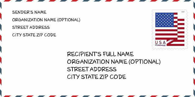
27007-6700 봉투 예제

-
이것은 미국 봉투의 예입니다. 왼쪽 상단에 보낸 사람 정보를 입력하고 오른쪽 하단에 받는 사람 정보를 입력합니다. 필요한 정보는 보낸 사람/받는 사람의 전체 이름, 주소, 도시, 주 및 우편 번호입니다. 수신자 주소 정보는 참조용으로 제공되었습니다. 일반적으로 전체 9자리 우편번호가 확실하지 않은 경우 패키지 분실을 방지하기 위해 5자리 우편번호만 입력할 수 있습니다.
27007-6700 기본 의미
-
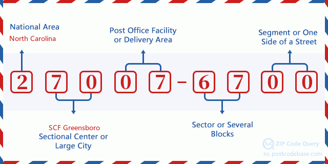
우편번호 27007-6700의 각 숫자는 무엇을 의미합니까? ZIP+4 코드는 두 부분으로 구성되며 처음 5자리는 우체국에 위치할 수 있고 마지막 4자리는 5자리 배달 지역 내 지리적 세그먼트를 식별할 수 있습니다. 6-7자리는 섹터 또는 여러 블록을 지정하고 8-9자리는 도로의 세그먼트 또는 한 면을 지정합니다.

- ·교통 노선 ID?
A 4-digit code assigned to a mail delivery or collection route within a 5-digit ZIP Code. The first character of this identification is alphabetical, and the last three are numeric: Bnnn = PO box Hnnn = Highway contract Rnnn = Rural route Cnnn = City delivery Gnnn = General delivery: R091 (농촌 루트)
- ·우편 추가 하부?
The ZIP Add-On Low Sector and the ZIP Add-On Low Segment together form the ZIP Add-On Low Number. The ZIP Add-On Low Number is the last four positions of a ZIP+4 code; the low-end ZIP add-on in a range of codes; the add-on of the first ZIP+4 code in a consecutive series of ZIP+4 codes assigned to the delivery address. For example, most delivery addresses are assigned a single ZIP+4 code. However, large companies may be given a range of ZIP+4 codes that can be used to route mail to specific departments. A range of ZIP+4 codes can also be assigned to a corresponding range of post office boxes, and each box is mapped, one-to-one, with a ZIP+4 code in the range. A single post office box can also be assigned a range of ZIP+4 codes.: 67
- ·우편 추가 낮은 섹션?
The ZIP Add-On Low Sector and the ZIP Add-On Low Segment together form the ZIP Add-On Low Number. The ZIP Add-On Low Number is the last four positions of a ZIP+4 code; the low-end ZIP add-on in a range of codes; the add-on of the first ZIP+4 code in a consecutive series of ZIP+4 codes assigned to the delivery address. For example, most delivery addresses are assigned a single ZIP+4 code. However, large companies may be given a range of ZIP+4 codes that can be used to route mail to specific departments. A range of ZIP+4 codes can also be assigned to a corresponding range of post office boxes, and each box is mapped, one-to-one, with a ZIP+4 code in the range. A single post office box can also be assigned a range of ZIP+4 codes.: 00
- ·우편 추가 높은 섹션?
The ZIP Add-On High Sector and the ZIP Add-On High Segment together form the ZIP Add-On High Number, which is the high-end ZIP add-on in a range of codes; the add-on of the last ZIP+4 code in a consecutive series of ZIP+4 codes assigned to the delivery address. Most delivery addresses are assigned a single ZIP+4 code; however, large companies may be given a range of ZIP+4 codes that can be used to route mail to specific departments. A range of ZIP+4 codes can also be assigned to a corresponding range of post office boxes, and each box is mapped, one-to-one, with a ZIP+4 code in the range. A single post office box can also be assigned a range of ZIP+4 codes. (See also ZIP Add-On Code.): 67
- ·우편 추가 높은 세그먼트?
The ZIP Add-On High Sector and the ZIP Add-On High Segment together form the ZIP Add-On High Number, which is the high-end ZIP add-on in a range of codes; the add-on of the last ZIP+4 code in a consecutive series of ZIP+4 codes assigned to the delivery address. Most delivery addresses are assigned a single ZIP+4 code; however, large companies may be given a range of ZIP+4 codes that can be used to route mail to specific departments. A range of ZIP+4 codes can also be assigned to a corresponding range of post office boxes, and each box is mapped, one-to-one, with a ZIP+4 code in the range. A single post office box can also be assigned a range of ZIP+4 codes. (See also ZIP Add-On Code.): 00
- ·우편 번호 추가: 6700
- ·범위?
The range of +4 codes. Summing the +4 Code and the +4 Range will give you the high end of the range of +4 Codes that pertain to this ZIP Code.: 0
- ·기본 대체 코드?
Code that specifies whether a record is a base (preferred) or alternate record. Base records (represented as "B") can represent a range of addresses or an individual address, such as a firm record, while alternate records (represented as "A") are individual delivery points. Government deliveries will only be listed on alternate records with the appropriate government building indicator (federal, state, or city) set.: 기본
- ·재무 수치?
A code assigned to Postal Service facilities (primarily post offices) to collect cost and statistical data and compile revenue and expense data. The state number comprises the first two positions of the finance number.: 360240
- ·국회 지역 숫자?
A standard value identifying a geographic area within the United States served by a member of the US House of Representatives or Senate. If Army/Air Force (APO) or fleet post office (FPO), this column will be blank. If there is only one member of Congress within a state, the code will be "AL" (at large).: 05
- ·마지막 줄 도시 주 코드?
An index to the City State file that provides the preferred last-line name for this address range.: Y14715
온라인 지도

주소입니다 6700 MEASHALL RD, ARARAT 상응한 온라인 전자지도입니다. 이동 및 줌 버튼을 사용할 수 있습니다. 지도 정보는 참고용입니다.
주소: 6700 (From 6700 To 6799) MEASHALL RD, ARARAT, NC 27007-6700, USA
댓글


댓글 달기